The Next Layer of City Resilience: How ApoSys Elevates Trunk Sewer Monitoring
Urban sewer systems are aging while storms are getting more intense. According to the U.S. Environmental Protection Agency (EPA), combined sewer overflows in the United States discharge an estimated 850 billion gallons of untreated wastewater and stormwater each year.
Wastewater infrastructure across the U.S. remains in poor condition, earning a D+ on the national report card, a clear signal of chronic under-investment and mounting systemic risk.
To manage these risks, municipalities rely on periodic CCTV inspections and manual defect coding under the Pipeline Assessment Certification Program (PACP). This framework, developed by the National Association of Sewer Service Companies (NASSCO), standardizes how defects are graded and reported. Yet despite its structure, the process remains time-consuming, subjective, and reactive, often identifying issues only after failures occur.
As storms intensify and networks age, this traditional approach cannot keep pace with real-time deterioration, leaving utilities exposed to escalating maintenance costs, environmental breaches, and service disruptions.
From Rail to Sewers: Why ApoSys
Built for rail corridors, our sensing, analytics, and dashboard stack adapts naturally to tunnels and large-diameter sewers. At Communitech's Fast Track Cities event, ApoSys clinched 2nd place, recognizing our approach to autonomous inspection and actionable analytics for critical infrastructure.
What Cities Are Demanding Beneath the Surface
Cities need inspection tools that work within these established standards while modernizing how data is captured and acted on. They are seeking systems that reduce confined-space entries, shorten turnaround from inspection to decision, and target rehabilitation funds where risk is highest. As climate volatility increases, utilities want monitoring that can predict failures before they happen, not just document them after.
The ApoSys Sewer Stack
Sage Framework. The foundation of ApoSys' sewer solution, integrating field hardware and analytics into one unified system for trunk sewers and interceptors. The framework includes:
-
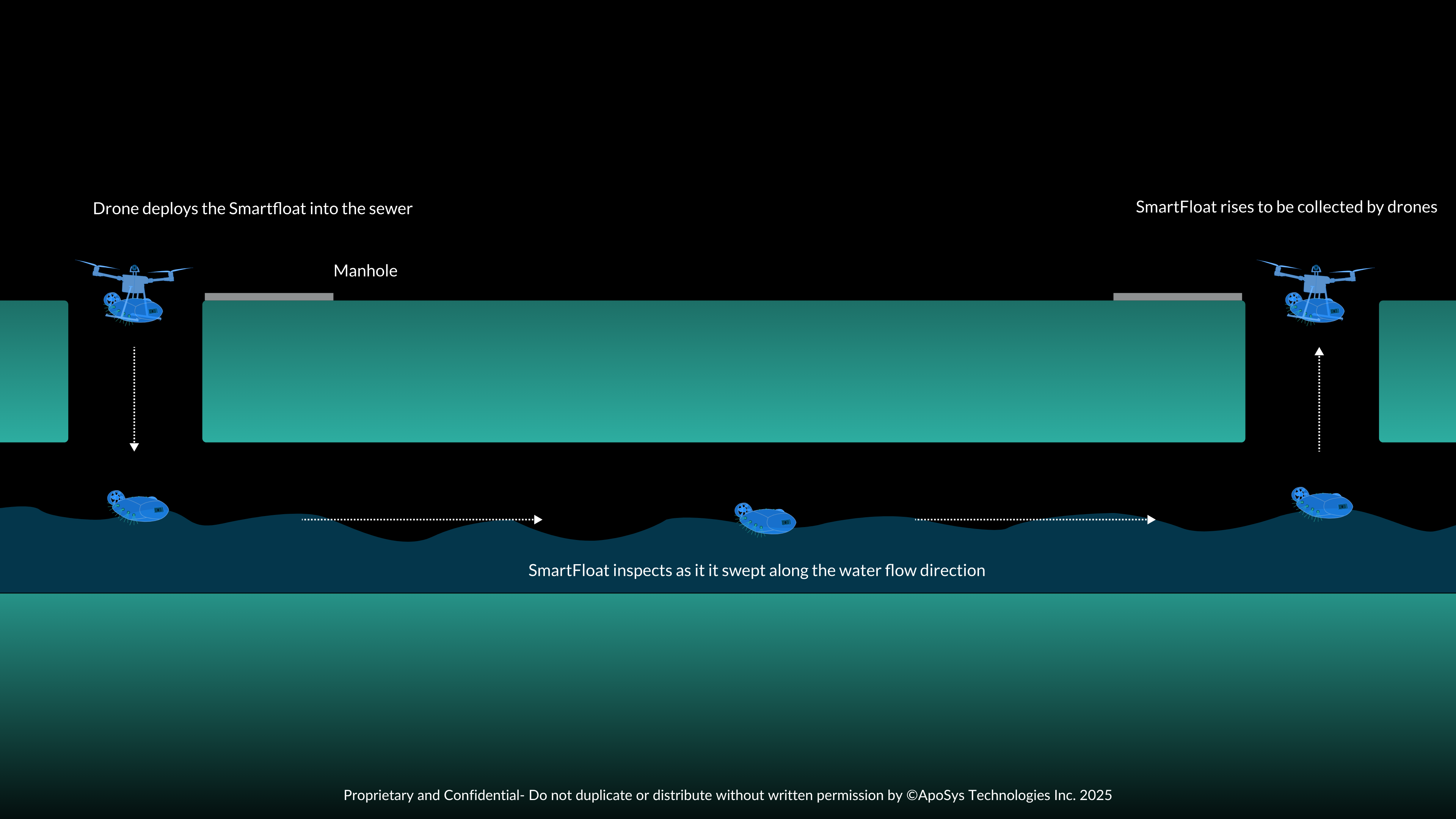
SmartFloat: An amphibious, remotely operated platform for both low- and high-flow conditions. It carries LiDAR and optical payloads to map geometry and detect defects even when partially submerged.
-
Multipurpose Drone: Designed for dry-weather entries, it captures high-resolution imagery and LiDAR data in large conduits where ground access is limited.
-
Remote Analytics Layer + Sage Dashboard: Converts raw captures into standardized, PACP-coded reports with trend views and actionable work packages so engineers can act quickly.
What It Sees, What It Flags
Cracks, fractures, collapses, and deformation reveal structural fatigue; deposits, roots, infiltration, and inflow signal operational strain; and misaligned or open joints expose underlying construction flaws that accelerate system deterioration.
Municipal engineers depend on this information not just for documentation, but to prioritize which segments to repair, reline, or replace. ApoSys automates that process. Using multi-sensor fusion: LiDAR, optical imaging, and flow-adapted sensors, our platform captures the interior geometry and condition of trunk sewers with millimeter accuracy, even in low-light or submerged environments.
The data is then processed through AI-assisted defect detection and PACP-coded analytics, producing consistent, audit-ready outputs that integrate directly with municipal asset management systems. Instead of weeks of manual video review, engineers receive an interactive map of risk zones, ranked by severity and type.
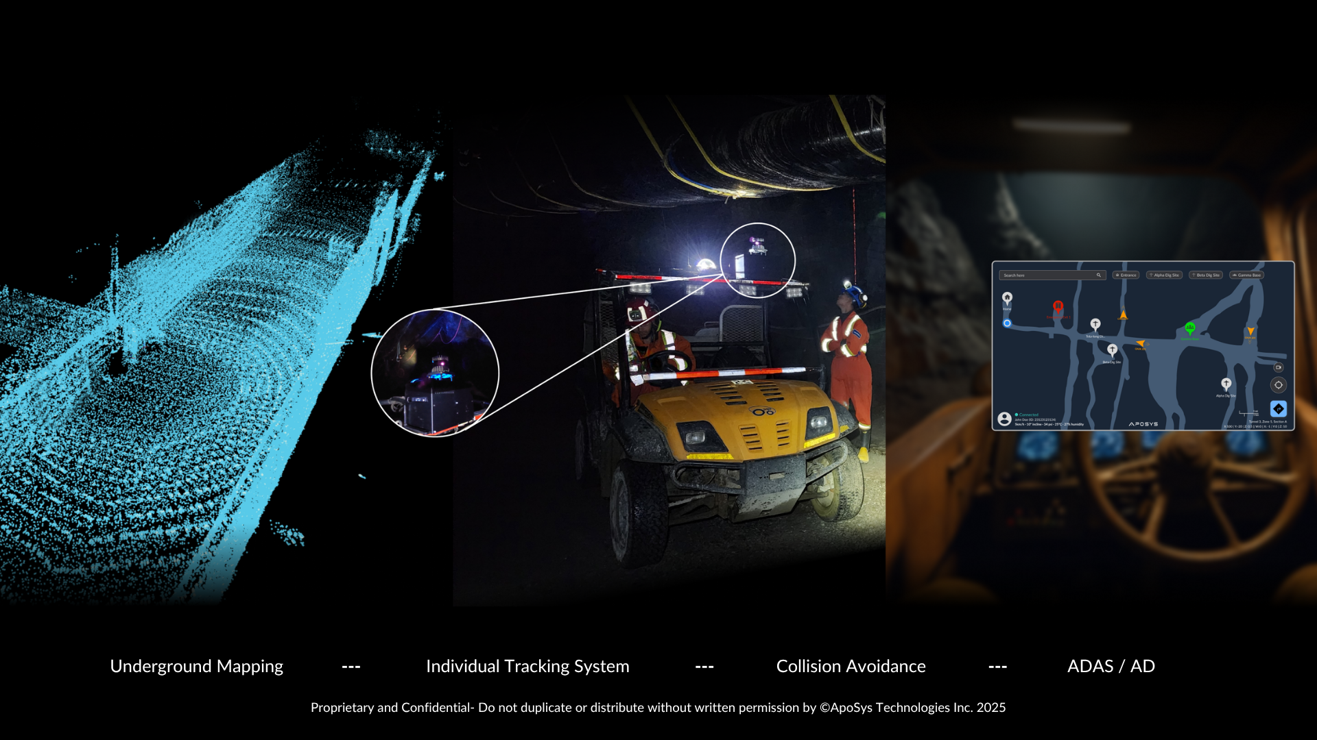
Why 3D LiDAR Matters Underground
In GPS-denied tunnels, LiDAR-based localization and SLAM deliver centimeter-class mapping and repeatable alignment between runs, enabling precise change detection over time. This is the backbone of ApoSys UGPS-style localization: reliable positioning and mapping in long, feature-limited conduits.
Built for Corrosion and Harsh Environments
Hydrogen sulfide-induced corrosion can cut a sewer's life from 50-100 years to as little as 10-20 years, making early detection and targeted rehabilitation essential. Our sensing stack pairs imagery with LiDAR geometry to spot lining defects, wall loss cues, and moisture-linked risk zones.
ApoSys is engineered to cut time-to-insight by automating defect detection, PACP coding, and map-aligned reports. ApoSys replaces episodic inspection with repeatable, multi-sensor surveys that shrink backlogs and enable targeted, trenchless rehabilitation where risk reduction is highest.
According to Deloitte's 2024 global analysis, enhancing infrastructure resilience with AI could prevent up to 15% of annual infrastructure losses, equating to roughly US $70 billion in avoided damage each year.
Compliance and Spill Reduction
Reducing CSOs and SSOs is both an environmental and regulatory imperative. The EPA's 850-billion-gallon estimate highlights how much is at stake for older Great Lakes and Northeast systems. Faster, data-rich condition assessment supports prioritized lining, infiltration control, and capacity management that directly reduce overflow volumes.
Roadmap: From Detection to Anticipation
Today, ApoSys delivers autonomous capture, PACP-ready analytics, and action-oriented dashboards. Next, we're advancing predictive layers that tie hydrology, flow, soil behavior, and traffic-induced vibration to forecast weak points and schedule interventions before failures cascade. The destination is the same one we championed in rail: continuous monitoring that informs tomorrow's fix today.
Why It Matters Now
Every deferred week risks another surcharge-driven rehab, backup, or CSO. With standard-compliant outputs, GPS-denied localization, and multi-sensor truthing, ApoSys helps municipalities turn inspections into decisions, and decisions into avoided spills, lower lifecycle cost, and healthier waterways.
Common Questions About ApoSys Sewer Monitoring
Q1: How does ApoSys handle data security and privacy for municipal infrastructure?
A: All data collected is encrypted end-to-end and stored on secure Canadian or client-specified cloud servers. Municipalities retain full ownership of their data, and we comply with ISO 27001-aligned security protocols to protect sensitive utility information.
Q2: How scalable is the system for smaller municipalities with limited budgets?
A: ApoSys offers modular deployment. Cities can begin with targeted trunk-line assessments or pilot corridors, then scale gradually into full-network coverage as savings from reduced emergency repairs accumulate: a pay-as-you-grow model that lowers upfront cost.
Q3: What role does UGPS technology play in sewers where GPS signals don't reach?
A: Our Underground GPS (UGPS) system uses LiDAR-based SLAM and onboard inertial sensors to maintain reliable localization in GPS-denied tunnels. This allows inspections to be aligned consistently between runs, supporting accurate change detection and longitudinal comparisons over time.
Q4: How does ApoSys contribute to environmental sustainability goals?
A: By detecting leaks, infiltration, and corrosion early, ApoSys helps reduce groundwater contamination and overflow incidents, cutting both carbon-intensive emergency responses and methane emissions from decaying waste. It turns maintenance data into measurable ESG performance metrics for municipalities.